


Lucerne abbaye et village

mousetik
User
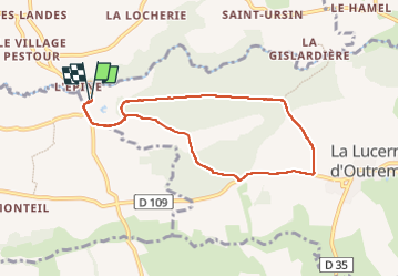

Length
7.2 km

Max alt
131 m

Uphill gradient
125 m
Km-Effort
8.8 km

Min alt
32 m

Downhill gradient
125 m
Boucle
Yes
Creation date :
2025-04-21 11:50:30.891
Updated on :
2025-04-21 14:05:02.414
2h14
Difficulty : Medium

FREE GPS app for hiking
 SityTrail
IGN / Geographical institutes
SityTrail Plus
The world is yours!
About
Trail Walking of 7.2 km to be discovered at Normandy, Manche, La Lucerne-d'Outremer. This trail is proposed by mousetik.
Positioning
Country:
France
Region :
Normandy
Department/Province :
Manche
Municipality :
La Lucerne-d'Outremer
Location:
Unknown
Start:(Dec)
Start:(UTM)
612545 ; 5405462 (30U) N.
Comments